Cuba's Early PopulationThe island that is known to the world as present day Cuba is located in the American Caribbean. The largest of all the Caribbean islands, Cuba is approximately the size of Pennsylvania with an area of 44,827 square miles and is 785 miles long from east to west. Cuba has a temperate tropical climate with abundant rainfall especially during the rainy season which runs from May to October.
The earliest evidence of human colonization in the Caribbean Island of Cuba has been dated to around 3500-4000 BC. Flake stoned tools were found at the earliest sites suggest the earliest migrants may have come from the Yucatan Peninsula and that these early settlers were hunter gatherers. No evidence has been found at these early sites that would suggest these people cultivated crops of any kind. Early migrants had to make great adaptations in order to survive their transition from the mainland. Perhaps the biggest difference between the mainland and island life would be the lack of large native mammals. The Islands in the Caribbean have been separated into two groups know as the Greater and Lesser Antilles. The Lesser Antilles consists of a group of smaller volcanic islands stretching from northeast South America all the way north to present day Puerto Rico. The Greater Antilles would be the Larger Caribbean Islands from Puerto Rico in the eastern Caribbean to Cuba in the West. It is hypothesized that the between 500 and 1000 B.C. peoples from South America began migrating their way up the Lesser Antilles and eventually settling the Greater Antilles including Eastern Cuba. They brought with them Dogs and domesticated crops including a root crop know as manioc, or Yuca. These migrants have collectively become known as the “Tainos.” It was with the migration of the Tainos and their culture that the population of indigenous peoples exploded across the greater Antilles and eventually in Cuba as well. The best estimates show that there were somewhere between 50,000 and 300,000 Indigenous persons living in Cuba at the time of Columbus’s arrival in 1492. The Tainos had villages across the Island, with complicated social Hierarchy’s. What the Tainos didn’t have though, was the ability to fend off the eventual takeover from the Spanish Conquistadors whose combination of Guns, Germs, and Steel would bring the collapse of Cuba’s indigenous population. Columbus made it to Cuba in his first voyage to the New World in 1492. He and his men brought with them things that the Cuban natives had never seen before. Namely, Disease and an ability to wage war and cruelty that the Tainos would be unable to fend off. By the year 1544 there were estimated to be no more than 7,000 people left on the island of Cuba with a large portion of those being Spanish as well as African Slaves. The native peoples had experienced a relatively homogenous development in the islands of the Antilles where as the descendants of the Spanish Conquistadors had developed into some of the most advanced peoples of the world. They had immunities to the diseases of the old world, highly developed crops, domesticated animals, and tools and weapons beyond the capacities of the native Cubans. So, while the peoples of early Cuba had made great strides from strictly small hunter gatherer societies to a more complex culture they were in no way prepared to meet the challenges brought in by the peoples of the old world. |
Map of the Caribbean Islands
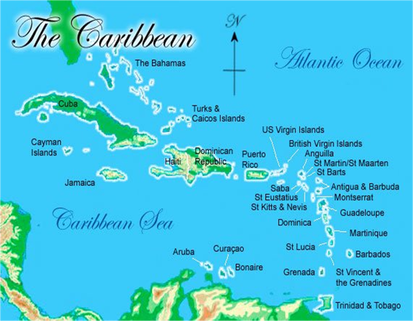
This is a map of what I referred to above as the Lesser and Greater Antilles Islands. The Lesser Antilles stretch from Trinidad and Tobago up to the U.S. Virgin Islands. The Greater Antilles make up the larger Islands of Puerto Rico, Jamaica, Hispaniola (Haiti, Dominican Republic), and Cuba. The Tainos people spread up from mainland South America through the Lesse Antilles and into the Greater Antilles.
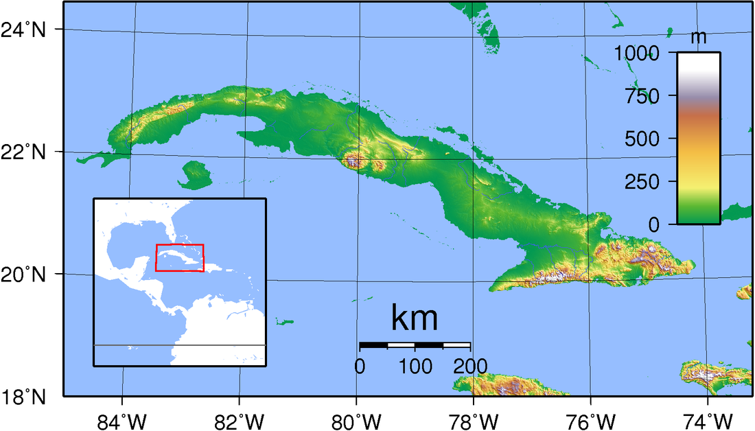
This is a map of Cuba's topography. Cuba has a warm, tropical climate. About one quarter of the island is covered in mountains and hills and the remaining lowlands are excellent for farming. Although not a meditteranean climate, Cuba's topography and weather would have made it an excellent candidate for human development. It's largest drawback being that it was an island in the western hemisphere with no ability to interact with the Old World during the dawn of human civilization.
Additional Sources from the Web
http://www.historyofcuba.com/
This website contains summaries regarding the people and the History or Cuba and is a quick and easy read in order to supplement the knowledge contained in the above narrative.
http://www.worldatlas.com/webimage/countrys/namerica/caribb/cuba/culand.htm
This Website has maps as well as information regarding the geography and climate of Cuba.
Citations
Staten, C. (2003). The history of Cuba. Westport, Conn.: Greenwood Press.
Wilson, S. (1997). The indigenous people of the Caribbean. Gainesville, Fla.: University Press of Florida.
Collins, F. (2012). Cuba. Chicago, Ill.: Heinemann Library.
Image Citations
Geography of Cuba. (n.d.). Retrieved September 15, 2015, from https://en.wikipedia.org/wiki/Geography_of_Cuba
Caribbean Map. (n.d.). Retrieved September 15, 2015, from http://www.customsailing.net/destinations/caribbean/caribbean-map/
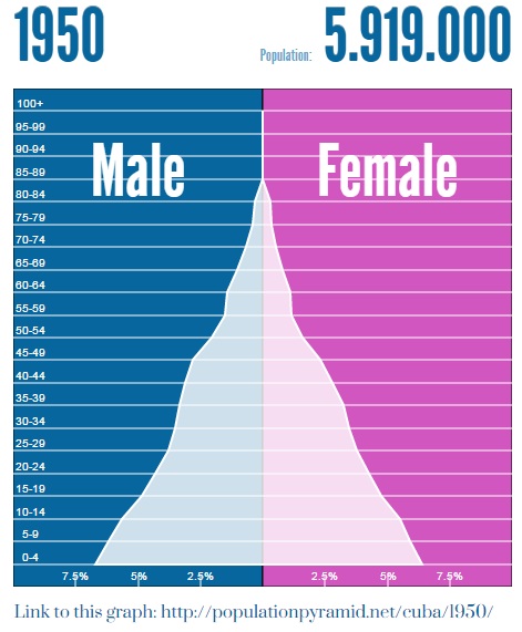
What we can see in this population pyramid from 1950 Cuba is that the country is in stage II of population development. People are benefitting from advances in medicine and sanitation creating longer lifespans as can be seen in the age groups of 50+ years. At the same time the largest amount of the population is in the 0-14 range meaning Cubans are still creating large families. This could be because of needs for the mostly agricultural population as well as the tradition of a large family. Soon though the costs of having many children will outweigh the benefits and this pyramid will begin to square itself out.
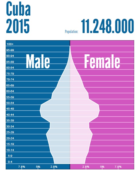
The first thing that stands out to me in this image is the size of the Cuban population. As predicted from the previous pyramid the bottom up shape indicated that the population would nearly double in the coming decades. Well it did from a population of approximately 6,000,000 to just over 11,000,000 people. The other major difference between the two is the shape. In 1950 the majority of the population was from ages 0-14. In 2015 the largest portion of the population is from 40 to 60 years of age. This tells me that in 1950 Cuba was nearing the end of stage II and with advances in medicine, technology, and education the nation entered stage III. In this stage the birth rate and the death rate tend to even out. The necessity for large families is no longer a priority and is actually unaffordable.
